Welcome to the page dedicated to SpotAiR icon legends
Preamble
SpotAiR displays many icons and some of them have specific meanings that are not necessarily obvious to understand. This page will help you to better understand all the subtleties.
| The base icon looks like this: |
 |
-
The practice is represented by a pictogram:
| Paragliding |
 |
| Hanggliding |
 |
| Speed-riding |
 |
| Kite |
 |
| Stunt Kite |
 |
| Boomerang |
 |
| Ice climbing |
 |
| Climbing |
 |
-
The status is represented by an overlay pictogram:
| Prohibited |
 |
| Prohibited without authorization |
 |
| Closed |
 |
| With recommanded pilot level |
 |
 |
 |
| IPPI 3 |
IPPI 4 |
IPPI 5 |
|
| Not covered by agreement |
 |
NB: The distinction between covered / not covered by agreement spots is only valid for France and Germany. For the rest of the world, this information is not available, so the distinction is not made. |
| FFVL agreement |
 |
| DHV agreement |
 |
-
The type is represented by an overlay pictogram:
Note that this information is only valid for certain practices: paragliding, hang-gliding, speed-riding
| Take-off |
 |
| Landing |
 |
| Training slope |
 |
| Winch platform |
 |
-
Appropriate wind directions are represented by green sectors.
Please note that these are general indications based on knowledge of the spots and do not
correlate with the actual weather conditions on the spot.
Some examples:
| Appropriate for North-East |
 |
| Appropriate for South, South-West et West |
 |
-
Unappropriate wind directions are represented by orange sectors.
Same, please note that these are general indications based on knowledge of the spots and do not
correlate with the actual weather conditions on the spot.
Some examples:
| Unappropriate for North et North-East |
 |
Appropriate for South, South-West et West
Unappropriate for North et North-East |
 |
-
The PWD accessibility is represented by an overlay pictogram:
| PWD accessible |
 |
| The base icon represents a windsock seen from above, it looks like this: |
 |
-
The direction is indicated by the rotation of the icon, the windsock is turned
to where the wind goes.
Some examples:
| Wind from North-West |
 |
| Wind from East |
 |
| Unknown direction |
 |
-
The average wind speed is indicated by its value in the center of the icon.
The unit of value is chosen in the "Display Settings" panel of SpotAiR, by default in kph
Some examples (kph):
| 12 kph West wind |
 |
| 3 kph wind, unknown direction |
 |
| West wind, unknown speed |
 |
-
The evolution of the average wind speed is indicated by a colored arrow downward (decrease) or upward (increase).
If no arrow is displayed, the trend is rather stable.
| Moderate upward trend |
 |
| Strong upward trend |
 |
| Moderate downward trend |
 |
| Strong downward trend |
 |
-
The status is indicated by the background color and a possible mention.
| Station "up to date" with a reading less than 30 minutes old |
 |
| Station with a reading older than 30 minutes |
 |
| Station with invalid |
 |
-
The evaluation of the suitability for your practice is indicated by the color of the ring of the windsock.
This evaluation is based on standard limit wind speed values.
Wind direction is not taken into account.
It is up to you, the practitioner, to keep your capacity of analysis according to the spots and the conditions met.
The limit values are adjustable in SpotAiR's "Display Settings" panel, with standard presets for free flight or kiting.
| Appropriate wind speed |
 |
| Too high wind speed |
 |
| Too low wind speed |
 |
| The base icon looks like this: |
 |
-
The direction is indicated by the rotation of the icon, the webcam points in the direction it is filming.
Some examples :
| Webcam filming towards the North-West |
 |
| Webcam filming towards the East |
 |
-
The status is indicated by the background color.
Webcam online and "live"
(the image has changed in the last 2 hours) |
 |
Webcam offline or frozen
(the image has not changed for 2 hours) |
 |
| The icon on the map: |
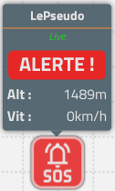
| Pilot in distress (sos mode activated) |
 |
| Cluster of pilots with at least 1 in distress (1/3 in this example) |
 |
| Cluster of pilots (14 in this example) |
 |
| Pilot is hiking |
 |
| Pilot is flying (or unknown state), heading unknown |
 |
| Pilot is flying (or unknown state), heading known (North-East in this example) |
 |
The colors and patterns of the pilots and wings are chosen randomly according to the nickname.
A pilot whose last position was more than 10 mins ago is grayed out. |
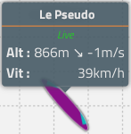
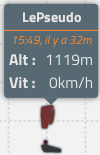
| Tooltip (displayed/hidden by clicking on the pilot icon): |
Pilot in distress (sos mode activated)
You can click on the tooltip to display the alert help dialog, see below. |
 |
"Live" pilot,
with altitude, vertical speed and horizontal speed info |
 |
Pilot whose last position was recorded at 15:49, 32 mins ago
with altitude and horizontal speed info |
 |
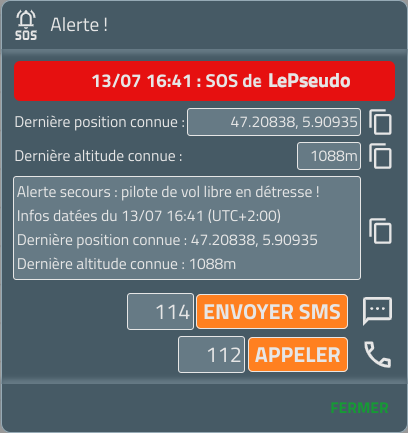
| Alert launch help window |
Clicking on the pilot in distress tooltip opens a window with essential information and shortcuts for alerting emergency services.
To call #112 or send a pre-filled SMS to #114 |
 |
| The base icon looks like this: |
 |
| If a boundary zone is defined, it appears as follows: |
 |
| Example of a Bearded Vulture MSZ: |
 |
| The base icon looks like this: |
 |
-
The snow height is indicated by its value in the center of the icon.
The unit of value is the cm (centimeter)
Some examples (in cm):
| Height of 43 cm |
43 |
| Height of 457 cm (4.57m) |
457 |
-
The status is indicated by the background color.
| Station whose reading is less than 3 days old |
 |
| Station whose reading is 3 days old or more |
 |
| The base icon looks like this: |
 |
-
The type is represented by a pictogram:
| Club |
 |
| Club-School |
 |
| School |
 |
| National education section |
 |
| Organizations |
 |
| Tandem flights |
 |
| Workshops |
 |
-
The business status is indicated by the background color:
| Non-Profit |
 |
| Unknown, or for profit |
 |


